

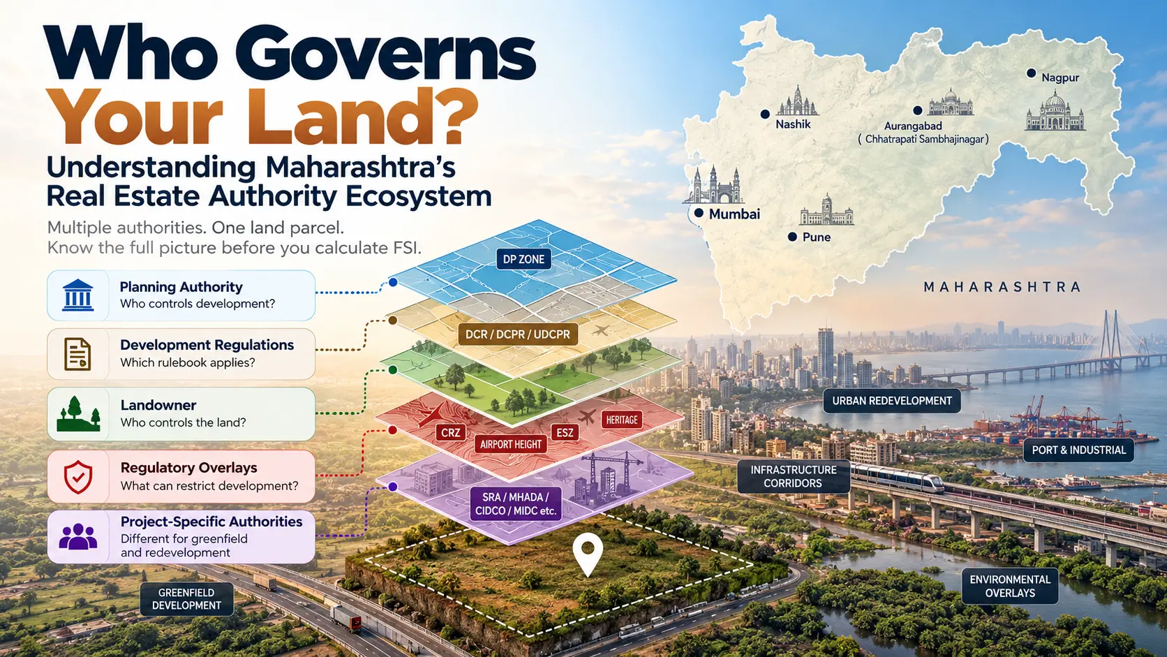
Before calculating FSI, project cost or land value, there is a more fundamental question every real estate developer needs to answer: Who actually governs the land? How many real estate authorities are in Maharashtra?
In Maharashtra, the answer is rarely a single authority.
A land parcel may fall under one Planning Authority, be owned or controlled by another authority, require environmental clearance from a third, and face height, coastal, heritage or infrastructure restrictions from several others.
For a Business Development or Land Acquisition team evaluating a new opportunity, getting this authority stack wrong can change the entire feasibility.
Consider a parcel in the Mumbai Metropolitan Region. Being located within the MMR does not automatically mean that MMRDA is the Planning Authority. The MMR covers approximately 6,328 sq km and includes nine Municipal Corporations, nine Municipal Councils, Khalapur Nagar Panchayat and more than 1,000 villages. Within this geography, different parcels can come under different planning and development regimes.
So, before asking “How much FSI can we consume?”, developers should first ask:
Who plans the land, who controls it, which regulations apply, and what other restrictions affect it?
Table of Contents
One Land Parcel Can Involve Multiple Authorities
One of the common mistakes during preliminary feasibility is treating every government body associated with a property as its “Planning Authority.”
They are not necessarily the same.
For practical feasibility, real estate authorities in Maharashtra can be understood through five broad roles.
1. Planning Authority — Who controls development?
The Planning Authority determines or administers the planning framework applicable to the parcel.
Depending on the location, this could involve a Municipal Corporation, Municipal Council, MMRDA, PMRDA, CIDCO, MIDC, SRA or another notified Special Planning Authority.
Its relevance includes questions such as:
- What land use is permitted?
- Which Development Plan or Regional Plan applies?
- Is the land reserved?
- Which Development Control Regulations apply?
- What roads or infrastructure are proposed?
- What development permission is required?
But even here, the answer cannot be inferred merely from the broader geography.
Take MMRDA as an example. MMRDA has a regional planning and development role across the MMR, but it also acts as a Special Planning Authority in specifically notified areas. For example, in July 2024, the Government appointed MMRDA as the Special Planning Authority for the MMR Extended Notified Area, covering notified villages in Palghar and Raigad.
The lesson: “Located in MMR” and “MMRDA is the Planning Authority” are not synonymous.
2. Landowner / Land-Controlling Authority — Who controls the land?
The authority controlling development and the entity controlling the land can be completely different.
A project could involve land belonging to or originating from:
- MHADA
- CIDCO
- MIDC
- State Government / Collector
- Port authorities
- Railways
- Defence
- Municipal authorities
- a private landowner
- a co-operative housing society
This distinction can fundamentally alter the transaction.
For example, MHADA operates through regional boards covering different districts across Maharashtra. A property involving MHADA land may therefore require examination not only of the applicable municipal development regulations, but also of MHADA ownership, lease, layout, conveyance or redevelopment conditions.
Similarly, authority-allotted or leasehold land should not automatically be evaluated like ordinary private freehold land.
Before acquisition, developers therefore need to ask:
Who owns the land? What is the tenure? Are there lease conditions? Is transfer permitted? Is an authority NOC or premium involved?
3. Development Regulation — Which rulebook determines the potential?
Once the correct Planning Authority is identified, the next question is:
Which planning instrument and development regulation actually apply?
Across Maharashtra, this can include:
- DCPR 2034 in Greater Mumbai
- UDCPR in applicable Maharashtra jurisdictions
- Development Plans
- Regional Plans
- Town Planning Schemes
- authority-specific development regulations
- Special Planning Area regulations
- notified redevelopment regulations
This is why simply knowing the city is insufficient.
Even within the Mumbai Metropolitan Region, the sanctioned Regional Plan, municipal Development Plans and specifically notified planning areas coexist. The current MMR Regional Plan framework includes the Regional Plan 2016–36; the remaining portion of that plan was sanctioned by the Government in April 2021 and brought into force from 20 June 2021.
For feasibility, the relevant question is therefore not:
“What FSI is available in this city?”
but:
“Which regulation applies to this exact CTS/Survey/Gat number and project type?”
4. Special Regulatory Overlays — What can restrict the theoretical potential?
Identifying the Planning Authority and permissible FSI still does not complete the feasibility.
A parcel may also be affected by:
CRZ — coastal location, creek, mangrove or coastal-development restrictions.
Airport height restrictions — permissible building height may constrain how much theoretical FSI can physically be consumed.
Forest / Eco-Sensitive Zone — environmental restrictions can materially change or prevent development.
Heritage — listed buildings and heritage precincts can restrict demolition, height, façade or redevelopment.
Road and infrastructure reservations — proposed DP roads, highways, metro corridors and other infrastructure can reduce the net developable plot.
Railway / Defence / Port restrictions — additional approvals or land-use restrictions may apply.
This creates an important distinction:
Permissible FSI is not always the same as consumable FSI.
A project may theoretically be entitled to a certain development potential but be unable to consume all of it because of height, setbacks, access, fire requirements, plot geometry or other restrictions.
5. Project-Specific Authorities — Greenfield and Redevelopment Are Different
The same parcel can involve a very different authority stack depending on what is being proposed.
For a greenfield project
The feasibility may primarily depend on:
Planning Authority → Land Use → Development Regulation → Road Width → FSI → Reservations → Infrastructure → Environmental & Other Overlays
For redevelopment
The sequence becomes more complex:
Planning Authority → Land Ownership → Existing Building/Occupants → Applicable Redevelopment Regulation → Rehabilitation Obligation → Incentive Development Potential → Sale Component → Other Approvals
Slum rehabilitation is a good example.
The Slum Rehabilitation Authority, Brihanmumbai is itself a Planning Authority for slum rehabilitation within its jurisdiction. Its functions include rehabilitation schemes, eligibility processes and building permissions.
Therefore, evaluating a slum redevelopment merely using the underlying municipal FSI would miss the fundamental regulatory mechanism governing the project.
Planning Authority ≠ Landowner ≠ Clearance Authority
Consider a hypothetical redevelopment opportunity in Mumbai.
The project could potentially involve:

The question “Which authority does this property come under?” therefore has no useful single answer.
A better question is:
“Which authorities influence the development potential, land rights, approvals and commercial viability of this property?”
A 6-Step Authority Check Before Evaluating Any Land Parcel
For a preliminary feasibility assessment, developers can follow this sequence.
Step 1 — Identify the exact parcel
Start with:
- CTS / Survey / Gat Number
- Village
- Taluka
- District
- Coordinates
- Gross plot area
A locality name or Google Maps location alone is not sufficient for regulatory feasibility.
Step 2 — Identify the current Planning Authority
Determine whether the parcel comes under:
- Municipal Corporation
- Municipal Council / Nagar Panchayat
- MMRDA
- PMRDA
- CIDCO
- MIDC
- SRA
- another SPA / NTDA
Do not determine this merely from the city or taluka name.
Step 3 — Identify the applicable planning instrument
Check the current:
- Development Plan
- Regional Plan
- Town Planning Scheme
- Special Planning Area plan
- DCR / DCPR / UDCPR
- subsequent Government notifications and amendments
Step 4 — Establish ownership and tenure
Determine whether the land is:
- Private freehold
- Society-owned
- Leasehold
- MHADA
- CIDCO
- MIDC
- Government / Collector
- Port
- Railway
- Defence
- other authority-controlled land
This can affect transferability, premiums, NOCs and redevelopment rights.
Step 5 — Identify regulatory overlays
Check for:
- CRZ
- Airport height
- Forest
- ESZ
- Heritage
- Mangroves
- Flood / river / nalla
- Highway
- Railway
- HT lines
- major infrastructure reservations
Step 6 — Only then calculate development potential
Once the above is established, evaluate:
Gross Plot Area
→ deductions / reservations
→ Net Plot Area
→ applicable FSI / development entitlement
→ rehabilitation or public obligations
→ premium FSI / TDR / incentives, where applicable
→ physical planning constraints
→ Actually Consumable Development Potential
→ financial feasibility.
This is the point at which a meaningful go/no-go decision can begin.
Why This Matters for Land Acquisition & Business Development
Early-stage land opportunities often arrive with limited information:
“4-acre redevelopment opportunity in Chembur.”
“10-acre land parcel near Panvel.”
“Industrial plot near Navi Mumbai.”
“Society redevelopment opportunity in western suburbs.”
But each description leaves unanswered questions that can materially change land value.
For example:
A parcel near Panvel could interact with a municipal jurisdiction, CIDCO/NAINA planning history, MMRDA’s newer notified areas, airport influence, an existing Regional Plan or a Town Planning Scheme.
Similarly, two neighbouring Mumbai redevelopment parcels can have different potential because of differences in ownership, existing occupants, road width, applicable redevelopment regulation, reservations or environmental constraints.
That is why regulatory due diligence should begin before land-price negotiation—not after it.
The Real Feasibility Hierarchy
Instead of thinking:
Land → FSI → Revenue
developers can think:

The biggest risk in early-stage feasibility is not necessarily making a mathematical error.
It is doing the right calculation under the wrong regulation.
Building a Better Feasibility Process
Maharashtra’s real estate regulatory ecosystem is complex because different authorities serve different purposes.
That complexity cannot be eliminated—but it can be structured.
For every new land or redevelopment opportunity, begin with four questions:
1. Who is the Planning Authority?
2. Who owns or controls the land?
3. Which regulation applies?
4. Which additional authorities or restrictions can affect the development potential?
Only after these questions are answered should FSI and financial feasibility follow.
For developers, Business Development teams and Land Acquisition teams evaluating multiple opportunities, this distinction can make the difference between identifying an opportunity quickly and spending days evaluating a project under the wrong assumptions.
Archonet’s Perspective
At Archonet, we believe feasibility should begin with understanding the land and its regulatory context—not simply entering an FSI assumption into a financial model.
LandWise is being built around this principle: helping real estate teams evaluate development potential, applicable regulations and key land-related considerations in a structured manner, so that early-stage opportunities can move toward a data-backed go/no-go decision faster.
Because before asking “How much can we build?”, the first question should always be:
“What actually governs this land?”
Information verified as of September 2026. Planning jurisdictions, regulations and authority boundaries may change through Government notifications and amendments. Parcel-level feasibility should always be verified against the latest applicable statutory documents.
What is a Planning Authority in Maharashtra?
A Planning Authority administers the applicable planning framework and development controls for a particular jurisdiction. The competent authority depends on the exact location and applicable statutory notification.
Is MMRDA the Planning Authority for all land in MMR?
No. Being within the Mumbai Metropolitan Region does not automatically mean MMRDA is the Planning Authority. Municipal corporations and other notified planning authorities operate within the MMR.
Is the Planning Authority always the landowner?
No. A parcel can be privately owned or controlled by MHADA, CIDCO, MIDC or another entity while development permissions fall under a different Planning Authority.
Should FSI be calculated before identifying the Planning Authority?
No. The applicable authority and development regulation should be established first because they determine the framework under which development potential is calculated.